

The Importance of Knowing Where You Are
There now follows a story about climbing a hill.
It is also a commentary on why, sometimes, you actually need to know stuff and take advice, even if you are very clever and often right about things.
I was a Scout for years. We were a pretty undisciplined lot – Baden Powell would have been unlikely to approve of our Embassy Regal and Skol lager consumption for instance – but I learned a bunch of stuff about the outdoors. In particular, I learned how to read a map properly.
When I left school I got a job catching salmon and used my wages to buy some proper mountaineering kit. That summer, hitchhiking most weekends to Braemar, I crisscrossed the Cairngorms and went to the top of pretty much everything. By the end of August, I was the colour of mahogany, had hands like leather and could easily cover 30 miles a day. Best of all – I really knew how to use a map and compass in fog when there is a strong incentive not to make a surprisingly sudden and rapid descent from Braeriach. Knowing exactly where you are on a mountain turns out to be an important life skill.
In the years that followed, I kept on walking. The thumb was replaced by my own car in the late 1980s and I learned some more advanced skills like how to use cross-country skis, how not to stab myself with an ice axe and how to tangle my crampons in my gaiters and fall on my face. But other than that not much changed, just me in the hills.
But this isn’t the story I want to tell you. No, this story really starts at 08.00 on a snowy January day in Bridge of Orchy.
Bridge of Orchy is a train halt and a pub about an hour from my house. I had a Sunday to myself and it was high time I headed up a mountain.
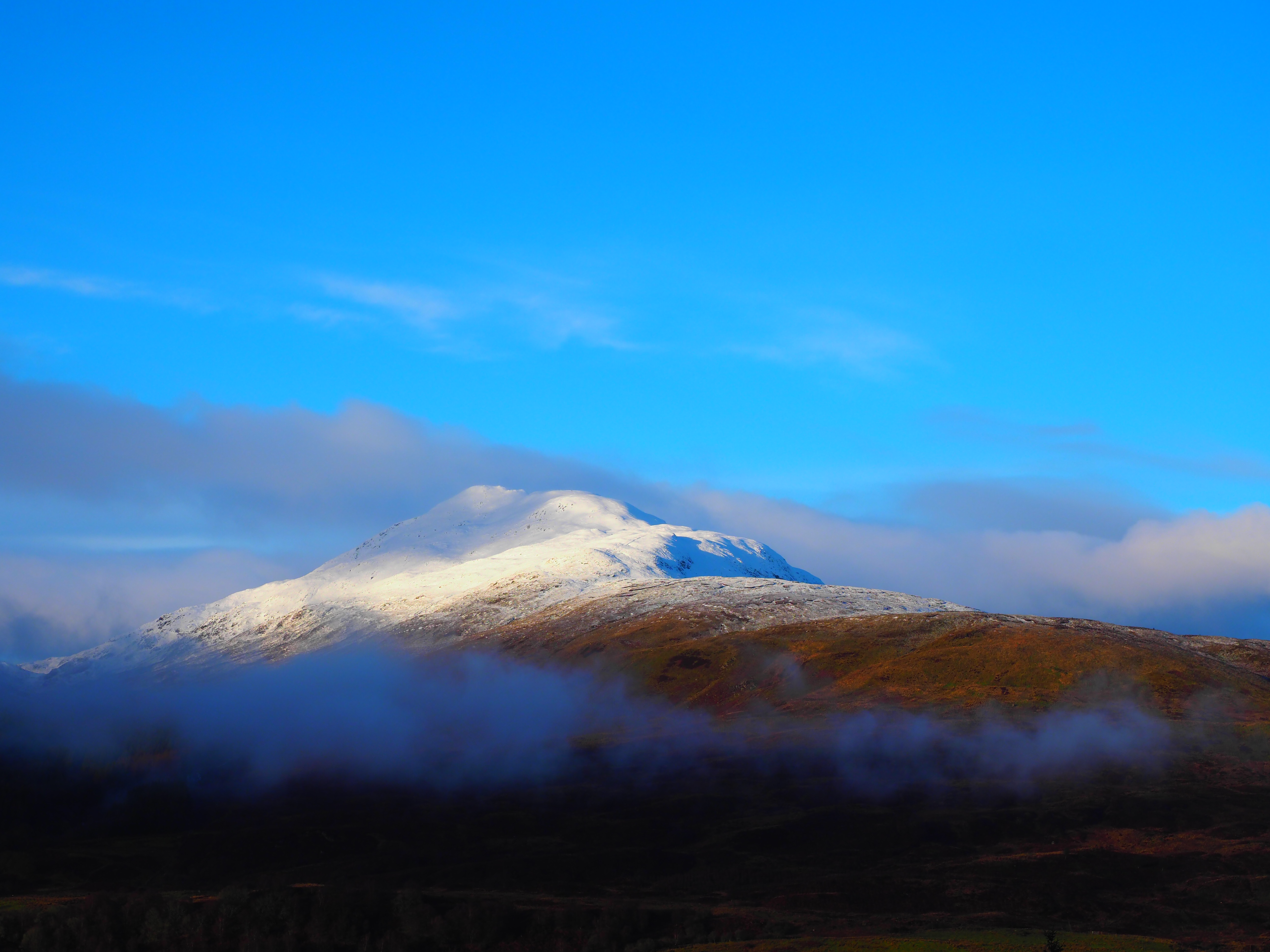
Today that mountain was Beinn Dorain – the “hill of the otter”. It is a fine mountain, 3,530 feet in old money. If you have ever visited Scotland and driven or taken the train to Fort William you will have passed it.
Beinn Dorain is not especially challenging in summer – walk east from the station turn south at the bealach (Gaelic for a pass) and keep going until you reach the top – there is even a path of sorts.
A foot or two of snow though and it becomes a little more, er, sporting.
The station car park was cold. Low cloud and an easterly wind carried snow and was blowing up the previous night’s fall. The weather forecast said that the cloud would lift and the wind ease gradually from the middle of the day though.
I headed off in the direction of “up”.
The path was well hidden under soft snow and I was the first on it that morning. The walk will take you three or four hours at a gentle pace in dry conditions. Today was clearly going to take a little longer.
In 200 metres the station disappeared from view in the snow and fog. I took a bearing and knew from the map that it was a matter of going in that direction until the ground fell away in front of me at the top of the bealach.
It was hard going and I was passed by ten fit looking people with a GPS system in the hands of the determined looking man at the head of them. “Hi,” I said. “Ugh,” came the response. They powered on ahead and were soon absorbed by the murk.
My life was slightly easier now as the GPS guys had broken a path of sorts in the snow. I reached the ridge after an hour and a half and started south along it. I had made a note of that compass bearing in pencil on my map when reading up on the route the night before.
Now I had left the shelter of the flank of the hill there was nothing to stop the wind whipping the snow off the ridge and exposing ice underneath. Time for the crampons. I cursed my frozen hands as I struggled to adjust the frozen straps but they were eventually secure.
I went on up the ridge towards the top. Everything on me was frozen with a fetching build up of snow on my pack. Helpfully my goggles decided to freeze as well so I had a choice of being blinded or actually being blind. I could keep my right eye more or less open and look at my compass. Excellent.
Looking at the guidebook the night before, I learned that Beinn Dorain has two tops and it is the more southerly of the two that is the taller by 20 metres or so and there are around 200 metres as the crow flies between the tops. I was coming down from the north so I knew that I would cross the lower top first and from there I knew how far I had to go and in what direction to reach the actual summit.
This would be a good time to tell you that civilian GPS in poor weather is (or was then) reliable to around 100 metres.
That ridge walk went on forever. Climbing something with one eye closed in a gale is surprisingly challenging. Eventually, though the slope came to an end and out of the gloom emerged all the grumpy guys with the GPS sitting on a cairn chatting away and drinking their soup. “Hi,” I said, “Ugh,” they replied.
“This isn’t the top,” I said. “Uh huh,” came the answer.
I walked on down the hill into the blowing snow. The surface was unbroken. Nobody had been this way recently. About 30 metres down, and well out of sight of the party on the top, the slope levelled out and then started upwards again. 10 minutes later and I had a big ice glazed cairn all to myself. I sat in the lee of the rocks took off my pack and fished out my own flask and a squashed peanut butter and jelly sandwich. Yum. I tried some chocolate which showed just how cold it was by not melting in my mouth and just rolling around in there like rubble in a cement mixture.
And then, just like the weather forecast had said it would, the cloud lifted and the sun came out on a clear and sunny winter afternoon. Ben Lui was throwing off its blanket of cloud to the south-west, I could see over to the Etive hills and Glen Coe to the north-west and further away there was a distant view of Ben Nevis, white against a china-blue sky. To the north I could see back over to the other, clearly lower, top, my own trail away from it in the snow, and, the key point: the GPS users had gone. They might have had an inspiring day but they had not got to the top.
They had not allowed for the margin of error, checked a map or cracked open a guidebook.
I headed back the way that I had come. The clear conditions made matters much easier than the climb. A couple of hours saw me back to the car and, through the windows of the hotel on the other side of the road, I could see my GPS friends with a pint congratulating themselves on a job well done.
I got in my car and headed home. As far as I am aware those guys still don’t know that they haven’t climbed Beinn Dorain.
So here is what I think:
- Being able to access new technology does not mean that you understand how to use it
- Do your homework
- Just because you do not want to engage with somebody that does not make their advice and skill any less important
- If you ignore advice and get something wrong why should anyone bother helping you out?
- Experience is the most important thing that you have and experience takes time
Anyway, a writer and shepherd by the name of Duncan Ban MacIntyre lived near Bridge of Orchy in the 18th Century and wrote a poem called “Moladh Beinn Dóbhrain” (“Praise of Ben Doran”). It starts:
“An t-urram thar gach beinn
Aig Beinn Dòbhrain;
De na chunnaic mi fon ghrèin,
S i bu bhòidhche leam..”
“Honour beyond each ben
for Beinn Dorain;
Of all I have seen beneath the sun,
the most glorious…”
I don’t think the blokes with the GPS will have read that either.